Thursday, August 16, 2012

Vacilando

Driving through northern Maine in the late autumn of 1960, John Steinbeck reflected on his planned road trip of discovery across America, still in its infancy. He recalled that the Spanish have a word that has no plausible counterpart in the English language. It is the verb vacilar, its present participle being vacilando. One might be tempted to translate them as “to vacillate,” or “vacillating,” but it does not mean this at all. This would imply that one has no goal or purpose in mind. If one is vacilando, it means that he or she - the vacilador - has a general inclination toward a place but is going nowhere in particular at the moment nor is there great care given to whether or not one actually arrives. Steinbeck tells his reader that this has become a state of being throughout Mexico and recalls walking the streets of Mexico, “We would choose some article almost certain not to exist there and the diligently try to find it.”

A vacilador appears to be very much similar to the flâneur in France; one who does not expect to arrive at any particular place with any specific plan in mind. In Steinbeck’s instance, he and his dog Charley wanted to travel to the northern most point in Maine, on the Canadian border, before beginning his long westward trek across the northern tier of states to his native California. Which roads he would ultimately take, which places he would visit, and whatever would occur along the way . . . and when and if he would complete the journey, would remain a mystery.

Although I am spending the summer in Maine, I look forward to exploring more of Washington’s neighborhoods and lesser known points of interest when I return home this fall. Where I will go, what I will choose to explore, and when I will eventually post my thoughts, is anyone’s guess. Life is an enigma.
__________ 
John Steinbeck. Travels with Charley: In Search of America. New York: The Viking Press, 1962.

Wednesday, April 25, 2012

McMillan Park


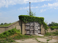
For over three decades I have been driving past McMillan Park, a 25-acre patch of green space situated off North Capitol Street at Michigan Avenue, NE.  The park is adjacent to the Bloomingdale and Stronghold neighborhoods and their rowhouses constructed around 1910.  It is also situated east of the McMillan Reservoir, formerly known as the Washington City Reservoir completed by the US Army Corps of Engineers, in 1902.  This reservoir joined the existing Dalecarlia and Georgetown reservoirs to hold water transported from the Potomac River by the Washington Aqueduct (completed in 1864) and continues to serve as the water supply system for the District of Columbia.  What makes McMillan Park unique, however, and what has long caught my attention, are the two rows of ivy-covered round brick silos.  Beginning in 1905, these functioned as key elements the city’s first sand filtration water treatment facility and a key component of the municipal water system.
  
McMillan Park was opened to the public circa 1910 and remained a popular and frequently visited commons created by the US Senate Park Improvement Commission, chaired by Senator James McMillan, a Michigan Republican.  This commission was largely responsible for expanding and enhancing Pierre L’Enfant’s original plan for the nation’s capital.  The park itself was designed by Frederick Law Olmstead, Jr. (1870-1957), one of this country’s preeminent landscape architects who managed to merge the park’s recreational possibilities with those of the engineering marvel hidden beneath it.  The park remained open to the public until the beginning of World War II when it was fenced in to protect the city’s water supply and the filtration system from sabotage. After the war, access remained restricted and the park continued to be closed to the public.  

The Army Corps of Engineers eventually replaced the park’s slow sand filtration system in 1985 with a newer and faster mechanical sand filtration system located across First Street, NW and directly adjacent to the McMillan Reservoir.  Instead of reopening McMillan Park to the public, the federal government declared the property surplus in 1986 and the District of Columbia government purchased it the following year.  Although obsolete and abandoned, the District recognizing its contribution to the growth of the city, designated it a historic site in August 1991 while continuing to restrict public access to the former park.  The fences remain in place while the District has entertained various plans to develop the site, each of which the local community has rejected in the hope of maintaining the historical flavor of the adjacent neighborhood and recognizing the park’s recreational and commercial potential.


This past weekend the local Advisory Neighborhood Commissions, non-governmental entities that advise the District government on issues affecting their local areas, sponsored an “open-house” at McMillan Park.  The gate was swung open, and after signing a waiver form, over 300 visitors were permitted to wander the entire site and have an up-close look at the long-abandoned water filtration complex.  


I was finally able to closely inspect these brick silos I have been admiring from a distance and to learn some of the history of the place.  This slow sand filtration system, which was first employed in the United States in 1872,  was designed to purify untreated surface water taken from the Potomac River and stored in the city’s reservoirs thereby making it potable and free from water-borne diseases such as typhoid and other communicable diseases.  According to the World Health Organization, "Under suitable circumstances, slow sand filtration may be not only the cheapest and simplest but also the most efficient method of water treatment" since they require little or no electricity or other mechanical power, chemicals or replaceable parts.

There is more here than first meets the eye.  Interspersed along the row of circular brick silos, which were used to store clean sand, are concrete sand washers and a series of small rectangular brick regulators houses that controlled the flow of water in and out of the twenty one-acre underground filter cells located beneath this broad expanse of grass.  There is also a paved promenade linking the various components of the water treatment facility.  Considering these structures have been abandoned and left to the elements for almost three decades, they are in remarkably good shape. 

The future of McMillan Park is currently unknown, but it seems to me that some sort of adaptable reuse can be found for this fascinating piece of Washington history.  It would be a shame for the District to allow unsympathetic developers to do what time and the weather have failed to do.  But the clock is ticking on McMillan park and I fear that money will speak louder than the rest of us.  I am glad I finally had an opportunity to see it.

Tuesday, April 24, 2012

Along the C&O Canal in Georgetown

Last December I met an old friend for lunch at Café La Ruche, on 31st Street, NW, in Georgetown.  Originally a small tobacco port town on the Potomac River, Georgetown was founded and named after King George II in 1751 and later incorporated into Washington, DC in 1871.  The building housing this popular French bistro was originally a private residence constructed circa 1830 on what was then known as Fishing Lane.  It remained a family residence over the years, and in the 1960s it served as the Market Playhouse and home to its popular repertory company.  Café La Ruche, which has long been my favorite watering hole in Georgetown, opened its doors in 1979.  “A bit of Paris on the Potomac.”

This lunchtime outing provided an ideal opportunity to wander along the C&O Canal as it transects Georgetown from its starting point at the former tidewater canal where Rock Creek flows into the Potomac River very near the Watergate complex.  Here, too, a skirting canal was constructed along the river to the Washington City Canal which followed what is now Constitution Avenue to wharves located along the Eastern Branch of the Potomac (now the Anacostia River).  I was able to walk the first mile of the 185 mile length of the C&) Canal as it parallels the Potomac from Georgetown to Cumberland, Maryland.

The canal was originally designed to allow for the transportation of goods and cargo from the head of navigable water on the Potomac to the headwaters of the Ohio River at Pittsburgh, in western Pennsylvania.  The Patowmack Company, established by George Washington in 1785, constructed a series of canals along the Virginia side of the river to improve navigation on the Potomac by bypassing the falls above Georgetown.  It eventually ceded its holdings to the Chesapeake and Ohio Company in 1824, and President John Quincy Adams broke ground for the new canal on July 4, 1828.  The first section from Georgetown to Seneca Falls, Maryland was completed and operational in 1831.  The remainder of the canal and its 74 locks, which raised or lowered barges 604 feet, were completed only to Cumberland in 1851, and in 1889 it came under the control of the Baltimore and Ohio Railroad.  The canal remained operational until 1924 when it was damaged by flooding and could no longer compete with the faster railroads.

The federal government took control of the obsolete canal in 1938 with the idea of transforming it into a National Park, plans for which were delayed by the onset of World War II.  After the war there was talk of constructing a highway along the river, and in 1954 Supreme Court Justice William O. Douglas hiked the entire length of the old canal to underscore its importance as a recreational area.  It was finally designated a National Historic Park in January 1971, due in large part to Douglas’ continuing efforts. 

My ramble began at the site of the former Tidal Lock, at the site of the Potomac watergate.  Rock Creek was originally damned at this site to create a tidewater basin where boats and barges could maneuver as they entered and departed the canal.  The lock is now badly disintegrated and silted in and there is no towpath adjacent to this lock.  It is necessary to walk past the Thompson Boat Center and take the bridge over Rock Creek to the beginning of the towpath on the edge of Georgetown.

At the time the canal was built Georgetown was a gritty, industrial port with warehouses,  foundries and mills located along its edges.  The towpath was originally on the river (south) side of the canal as far as what is now 29th Street, NW (formerly Green Street) to avoid interfering with the wharves that were expanding along the riverfront to handle coal, building stones and other cargo following the construction of the canal.  Today the canal walk in Georgetown, runs entirely along the north side of the canal and the first four locks, which are situated very close together in the first mile, still contain water and are some of the best preserved locks on the entire canal.  Walking here one can get a real sense of what it was like over a century ago.

It was a delightful lunch at Café La Ruche, all the more so given a beautiful day for a quiet stroll along the canal.  I must come back here when the weather warms up, but it is a treat regardless of the season.   

Friday, March 30, 2012

Time to Venture Forth Again . . . .

It has been a mild winter and so it has not been the weather that has kept me from exploring the city. The plain fact of the matter is that I have been terribly busy coupled with the fact that I also made an extended road trip to the Canadian Maritime in January, and I have recently returned home from a long trip across the Midwest to North Dakota (you can read about these trips at www.lookingtowardportugal.blogspot.com ). But Spring has finally sprung in Washington, DC and it is time again to venture forth and see what the city has to offer. I hope you will join me.